Introduction
This paper focuses on the role and importance of IT in ground water management. It provides groundwater management definition, explains the key phases of the process and the challenges connected to it, and analyzes a series of interviews on the topic.
During the last twenty years, the use of information technology has mushroomed and proliferated throughout almost every discipline. It is being used in everything from waste management to farming. Not only does it offer fast processing of information, but accurate measurement, digital testing of all kinds of processes and materials, and immense storage capability. New uses for information technology have been developed due to the use of information technology. Applications have been developed that would not even be possible without digital processing. Sciences of all sorts are major beneficiaries of this boon, and groundwater management is among these.
Information Technology is a compound noun, and each part has its meaning. Since the compound noun is very close to the definition of the two nouns which form it, we will use these to explain it. Information is data, otherwise known as facts, which has been put into a human usable form. Technology is the use of created tools. So information technology would be the use of tools to store, manipulate or process data that has been put into a human usable form. The data which comes into the processing system may not be information, because the result of the processing may include creating information from it.
Groundwater Management Definition
Groundwater Management is a relatively new technology, though certain portions of it have been around for centuries. Canals, irrigations ditches, dams, and water storage are all technologies that are included in groundwater management. Management of groundwater is the control of the quality, storage, use, and conservation of water in or on the ground. Most of our water is stored either in visible surface bodies, such as lakes, rivers, and oceans. However, there is much more water below the surface which also applies, and this is far more important than what is seen on the surface. On groundwater management, we mostly concern ourselves with freshwater supplies, and there is as much or more of this underground in many places as on the surface. Underground water is also easier to store but more difficult to manage.
Groundwater Management Phases
There are four phases to Groundwater Management:
Tracking and Mapping
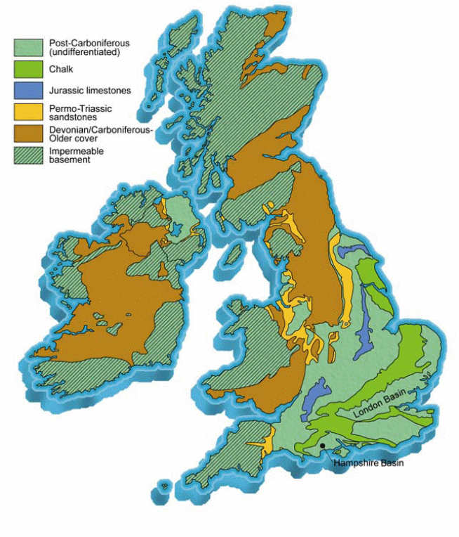
Engineers need to know where the groundwater is, how much is there, and the speed of accumulation and dissipation. Information is acquired from various sources: information feeds from Internet 2, satellite feed, incoming transmitted information from field instrumentation or from agents in the field. Here is an example of one map:
Quality testing and Monitoring
The groundwater must be tested for impurities and solutions to problems must be devised.
Research and Development
- Research is constantly looking for new ways to manage groundwater, new solutions to problems, and new methods for accurate predictions.
- Education programs keep everyone up to date on the science and new developments of groundwater management.
Application of Management Projects
Work is always ongoing to control groundwater use, accumulation, and quality.
The information technology types, software, needed for effective groundwater management include the following:
Using this, the aquifer can be monitored, and new geological surveys can be converted into usable information. Information, measurements, and sensor data from all the various sources can be used to create whatever maps or images the researchers and engineers may need. This also includes data modeling software used by most earth sciences. It can convert raw data to any number of different output models. It also converts information gathered from public sources, such as the conversion of a multidimensional data model and a data mining tool in the earth sciences is carried out by the International Council of Scientific Unions’ World Data Center system (WDC). The group works to guarantee access to any data in all fields of earth science on a long-term basis. Images are really important in this science.
- Testing control software automates the testing of samples for virtually any chemical compound. Some of this software may be included in PDA’s or tablet PC for field technicians. Others will be used in the lab. The software controls the testing equipment and analyzes the results. Technicians, planners, and engineers will use this information for planning projects and for designing solutions.
- Machinery control software controls the operations of machinery designed to manage groundwater. These are numerous and vary, including things like automatic locks on canals, dam overflow controls, fish wheels, ground sensors that trigger alarms or processes. This kind of software provides a means for 24/7 monitoring and automates machinery needed to move groundwater.
- Simulation software helps engineers make decisions by offering a way to conduct “what-if” scenarios in virtual reality using all the information gathered concerning the problem(s). This may be the most useful software, besides the testing software. This software allows engineers to simulate the different problems with groundwater and try different solutions. Many new creative solutions have been found this way.
- Management software takes care of everyday operations, HR, and business processes. There is word processing for letters, spreadsheets for charts, accounting software, presentation software (PowerPoint) for seminars and meetings, desktop publishing software, email software, the operating systems on desktop computers, the laptops, and the mini-mainframes, an HR software for the time clock, for payroll and such, project management and contract software. All of these are used daily in administration by office personnel, accountants, finance people, receptionists, and planners. Technical writers use them for creating content for the website and the newsletter.
- Communications software keeps employees connected and connects them to outside experts, government officials, other companies, etc. These include email, messengers, and bulletin boards for chatting and sharing ideas, A whiteboard offers the ability to share across a connection. Everyone uses these.
- Educational software for ongoing learning initiatives and training. Many training packages offer employees the ability to keep up with the scientific developments in groundwater engineering. There is also usually a virtual library for employee use. HR uses this for new employee orientation and ongoing employee training.
- Software for data collection in the field, generally running on sturdy tablet PCs or PDAs. These are usually custom-designed for specific purposes. All the researchers, technicians, and engineers use this.
- Databases for storage of raw data and results. Most of these are big multi-user databases that can be easily queried, such as SQL or Oracle. Most employees use one or more of these.
- Website construction and maintenance software. There are several good packages for this. Most companies and government departments do have websites, so these are needed. They may also have Intranets and VPNs (virtual private networks) which are secure ways for employees to connect to the network from a remote location over the Internet. The webmaster and the technical writers use these.
- Network management, security, and maintenance software. A good network management system includes monitoring activity, limits access to certain areas for certain people, promotes good connections, but safety from outside intrusion. The management of a network controls email and logins, passwords, installed software, and protects against the loss of data with regular backups. The network software logs all activity and analyzes it regularly for suspect behavior. This includes too much email going out, too much data being downloaded, and inappropriate content on certain machines. The use of all of these is limited to the IT department, though it runs on all company machines.
Ground Water Management: Interviews
Interview with Zhao Sui, a geological engineer with China Petrochemical Corporation in Beijing, conducted via Skype:
We used her English name Sue since she prefers it when speaking in English. Introductions and farewells are left off the transcript as are all personal remarks.
Me: Sue, How long have you been an engineer?
Sue: Oh since I left university after completing my Masters, about 9 years now.
Me: So what is your function at China Petrochemical?
Sue: I look over the topographical maps and recommend where to look for more deposits of oil and coal. I also calculate the required distance for drilling and I check that we will have no trouble with the job. I check the findings of on-site engineers and I help decide where we will drill for oil.
Me: What about groundwater? Do you have anything to do with that?
Sue: Oh yes, we have to protect groundwater, since in many places we have little. I am careful that our drilling will not impact groundwater, especially since we often use mud pumps to help with production. So we have to get much knowledge of the environment and the water table is part of that.
Me: So is groundwater management part of your specialty?
Sue: No, but I took some courses and went to special courses in Houston, Texas to study the latest technology for environmental protection.
Me: So what software do you use on the job?
Sue: Oh many software, we have some of our own that are for making the maps and they make three-dimensional pictures of the geology and I can turn them any way I need. It models the ground for me, shows the rocks and soil and water, everything. I also use Word for reports and Excel for my charting of the data, and email of course. Then we use a blackboard that is white like the one used for presenting a topic, but it is on our computers when I talk to engineers on site. That way we can share pictures and make notes on them. I also use Matlab and some drawing software for the plotter. I also have a little contact manager and we have a DSS on the Intranet I sometimes use.
Me: Did you always use these tools?
Sue: Oh no, some of these are very recent. When I started I have a computer with word and excel and some really poor analysis tools plus Autocad.
Me: Did you like it when they put in the new software?
Sue: Oh, no, I did not think I could learn it, but they said it was easier than Autocad or Matlab, so I took training classes and learned to use it all. Now I like it. Nobody should try to take it away from me now.
Interview with XXXXXXXX XXXXX CIO of XXXXX XXXXX
Me: So could you please tell me what your company does?
XXX: Well we are a government agency really and our job is to keep track of groundwater the supply is steady and clean and where it needs to be.
Me: How does your company use information technology?
XXX: Oh everywhere. The company would not exist without it. I mean groundwater management was very primitive before computers. Everything had to be recorded by hand and plans drawn up on paper. We could not do much without computers. I mean we could dam water and channel it, but there was no science to it. Now we have imaging systems, simulation software, computerized analysis, and then just keeping up with the large staff and all the benefits the government requires keeps two HR people busy full time even with the software.
Me: So you always had the software you use now?
XXX: NO, the software has changed. Gotten more sophisticated over time and much more powerful.
Me: Can you give me an example of a change that made big changes in your work?
XXX: Sure. I used to have to make a lot of notes and have a secretary at meetings to take minutes and then I had to plan things out on paper or in my head, and I could never be sure I had thought of everything. Now I have recordings of meetings transcribed by software to text and a secretary distills it down to the essentials for me. Then I use decision support software to help me stay organized and make sure I remember all the points I need to consider.
Me: Did that make things easier right away when you made the change?
XXX: No not at all. I had to learn the system. For a while, I was stressed and using both methods.
Me: So have any software upgrades or new technology made huge changes in departments?
XXX: Oh several.
Me: Could you briefly describe one and how it was received by personnel, please.
XXX: Aaaah, yes, we got new imaging software about 10 years ago, and the engineers were excited about it, but it eliminated some jobs with Autocad because we did not need so many people using this, since the imaging software did it automatically. So it eliminated some jobs, but most of those people were retrained and moved into other work since their computer skills were really valuable and they did not want to leave the company. Now every change has worked so well, but we have had several bog changes, so the people get used to it.
Me: How do you mean?
XXX: Well our people are used to the idea that our technology changes and their jobs have to change with it. Even the engineers go to classes now and then to brush up. We pay for them, of course.
Me: So bringing in new technology is not a traumatic change for you?
XXX: No, not at all anymore. We have changed so many times we start talking about the next development almost with excitement. Some of our engineers even send comments to the developers to request certain functions in the next iteration. Most of these guys see new software like a carpenter sees new power tools, with excitement. Now the administration is not the same. I would not even consider saying switching our accounting software unless I had to. The accountants would be impossible. But new tools for the engineers: they love it.
Reviews of IT Articles
Exploring Technology Adoption and Use Through the Lens of Residential Mobility by Shklovski and Mainwaring (2005)
This paper reports on an exploratory ethnographic study of the role of contemporary ICTs in the event of a long-distance residential move. The researchers “found ICTs to be implicated throughout, as they were used in planning and executing the move, orienting to the new location, keeping in touch with the old location, and re-balancing one’s social network between old and new locations.”
The researchers found that technology was helpful for the people who were moving, even if it made the work of the movers a little more complicated. Older personnel would have had a more difficult time adopting the technology. The use of ICT technology certainly makes moving long-distance less traumatic than in times past. We note “that the primary author is involved in a
large-scale longitudinal quantitative study of residential mobility within the United States, from the perspective of ICT use and social network health.” (Shklovski and Mainwaring 2005)
Studying the Current Status of Technology Adoption: Examining the extent and nature of adoption of technologies by micro, small, and medium-sized manufacturing firms in the greater Boston area by PRATYUSH BHARATI and ABHIJIT CHAUDHURY
This article was highly informative on the methods, consequences, and reaction to bringing in new technology to SMEs (small and medium-sized enterprises). It also includes a great deal of information on software types.
The abstract includes some interesting statistics: “SMEs employ approximately half of all private sector employees, generate 60% to 80% of new jobs annually, and employ approximately 40% of high-tech workers such as scientists, engineers, and computer workers.” ((Bharati and Chaudhury 2006)
This chart from the article shows some of the information they discuss.
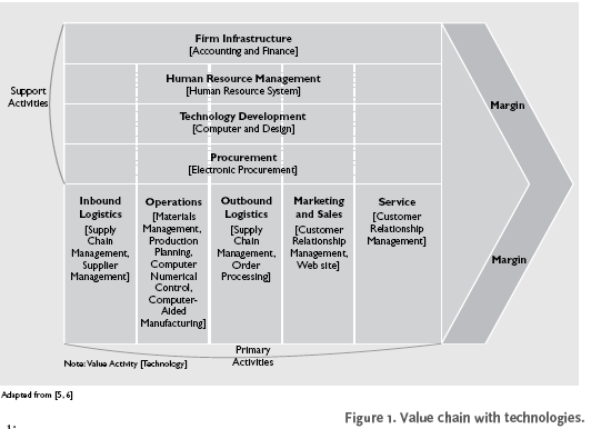
The following chart from the article shows the various areas using information technology. It also shows the percentage of each size firm that used it for these areas. Since groundwater management is generally quite a large undertaking, these departments and contracted firms would probably use most or all available systems.
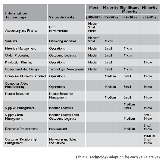
Information technology has simply permeated all areas of business and management.
The article concluded with an analysis of the adoption rate of technology among SMEs and found that the problems now are not resistance to adoption but a lack of awareness as to available technology.
Requirements Engineering for Organizational Transformation by Isabel Ramos and Daniel M. Berry
This article is a research project to identify emotional reactions to the adoption of new technology in companies and methods that might mitigate the stress of this adoption. The article covers a large research project on Portugal at several companies and makes recommendations for adopting an approach that reduces the emotional reactions among employees. It introduces the reader to the reasons for the resistance to new technology and the basis in the value system of the employees.
From IT Application to Organizational Transformation by Frank Lamb, London School of Economics
This article ascribes the reaction of users to the implementation of new technology to the IT department’s failure to make the ROI (return on investment) clear to the prospective users because they concentrate too heavily upon applications instead of business functions.
Appendix A
List of Available Software for Groundwater Management
This list includes available software for the specialization of Groundwater Management. It does not include all the usual software for business operations.
Software by Category.
| 2D and 3D Groundwater Data Visualization Software Our visualization software offers the most flexible environment for creating rich, interactive animations and graphical designs of groundwater and environmental data. With these tools, you can now produce high-impact reports and more engaging presentations.  |
| Advanced Groundwater Data Management Software Whether managing groundwater, borehole, or environmental data, conducting an in-depth analysis of aquifer vulnerability, visualizing vasts amounts of data in three dimensions, or preparing effective reports, our advanced groundwater and borehole data management software applications ensure your entire team has access to the tools required to complete the project efficiently. Our groundwater and borehole information management software provides you with a complete understanding of your data so you can deliver superior projects and engaging presentations. 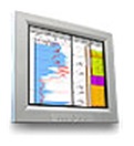 |
| Borehole Geology Logging Software Our borehole log plotting and subsurface characterization programs deliver easy-to-use graphical tools with advanced interpolation algorithms to easily visualize your geologic data. Now you can conduct in-depth borehole analyses and investigations with ease. 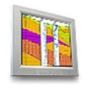 |
| Diver Data Management Software Groundwater data management software is used to program and read information from your Diver Dataloggers.  |
| Groundwater Modeling Software Predict the future or look into the past with an impressive line of advanced three-dimensional groundwater flow and contaminant transport modeling and simulation programs. A complete range of comprehensive features and powerful capabilities makes delivery simple or complex groundwater site investigations a reality. 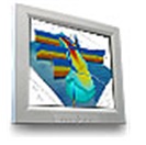 |
| Natural Attenuation & Remediation Optimization Software Understand contaminated flow regimes. Store and manage site remediation data. Optimize pump and treat, funnel and gate, or embrace monitored natural attenuation as a remedial strategy. These software applications guide you through various stages of your remedial optimization process so you can achieve superior removal of groundwater contaminants from contaminated sites.  |
| Parameter Estimation & Statistical Software The most powerful non-linear and automated model calibration package available. Our Parameter Estimation and Statistic application combine advanced parameter estimation capabilities with superior graphical processing. You can now estimate parameters for just about any groundwater model.  |
| Pumping Test And Slug Test Data Analysis Software Designed by hydrogeologists for hydrogeologists, our Pumping Test Analysis programs incorporate numerous high-demand analysis methods to help you expand your graphical analysis and reporting of pumping test and slug test data. What you get is a flexible environment to determine the hydraulic properties of your aquifer and customizable reports.  |
| Surface Water Modeling Software Simulate basic or complex hydrodynamic conditions; prepare surface water models for analysis and evaluation; manage and plan water resources; perform FEMA-approved modeling of floods. Our surface water modeling packages are considered industry-standard by environmental consultants, government agencies, and educational institutions alike. 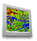 |
| Unsaturated Zone Modeling Software Integrating the latest methods for visualizing and managing projects, generating and sharing input data, and presenting modeling results, our Unsaturated Zone Modeling applications allow you to effectively predict flow and contaminant migration within the unsaturated zone.  |
The EQWin suite consists of the following products
- Erwin Data Manager
- EQWin Modules
- EQWin Language Translator Module
- EQWin/GIS Interfaces
- EQWin/ArcGIS8 Interface
- EQWin/MapInfo Interface
- EQWin Sample Manager
- EQWin Compliance Manager
Open Directory Project
Argus Open Numerical Environments – A family of general-purpose public-domain graphical pre- and post-processors for the numerical modeler, combining GIS and numerical modeling. Includes plug-in extensions for the most widely used groundwater models, including MODFLOW, MOC3D, HST3D, SUTRA, and NAPL.
- BOSS International Groundwater Modeling Products – Offers GMS, FEFLOW, and other groundwater software programs. Also has products for hydraulics and surface water hydrology.
- Discerning Systems Inc. – Hydrogeochemical exploratory and statistical tools for analysis and management of monitoring data at landfills and industrial facilities.
- EasySolve Software LLC – Offers low-priced software for environmental and earth science professionals — creates boring logs, calculates hydraulic conductivity, creates variogram plots.
- Ecoseal Developments Pty Ltd – Provides software, groundwater monitoring equipment, and magnetic instruments for environmental, agriculture, mining, and education sectors.
- Environmental Insite – 3d groundwater visualization application for analysis and communication of environmental groundwater data. Capabilities include mapping, 2d/3d contouring, pie charts, time history charting, radial diagrams, and database queries.
- Environmental Simulations, Inc. – Groundwater modeling software, services, and training, including sales and technical support for WinFlow, WinTran, MODFLOW-Win32, Groundwater Vistas, and AquiferWin32.
- FEFLOW – A finite-element simulation package for 3D and 2D density-dependent flow, mass, and heat transport processes in groundwater and the unsaturated soil. Description, pricing, and downloadable demo, from WASY Ltd.
- Ground Water for Windows Software – Software combines a relational database and a Ground Water Information System (GWIS). Applications include mapping, well logs, aquifer test analysis, and plotting of water chemistry data.
- GroundwaterSoftware.com – Purchase groundwater software now and download it immediately at discounted prices. Many applications are available: flow and transport modeling, slope stability analysis, landfill design, and geostatistics.
- HydroBioGeoChem 123D – For simulation of coupled non-isothermal (i.e., includes heat transfer equations) hydrologic transport and biogeochemical kinetic and/or equilibrium reactions in variably saturated media. 1-, 2-, or 3-dimensional.
- HydroSOLVE, Inc. – Developer of software tools for groundwater modeling and aquifer test analysis.
- Hydrus-2D – A software package for simulating the two-dimensional movement of water, heat, and multiple solutes in variably saturated media.
- IGWMC Groundwater Modeling Software – International Ground-Water Modeling Center distributes a large number of practical, public domain, and proprietary ground-water programs, ranging from codes based on simple analytical solutions to those incorporating advanced and complex numerical techniques.
- MicroFEM Groundwater Flow Modeling – Offers several programs for applications including multiple-aquifer steady-state and transient flow, aquifer test analysis, and interpretation of geo-electrical measurements with Schlumberger or Wenner configurations. Downloads available.
- MODFLOW and related programs – USGS’s popular modular 3D finite-difference ground-water flow model, plus pre-processors, post-processors, and adaptations for contaminant transport, and airflow.
- The MODFLOW help file – Resources for users of the USGS-developed MODFLOW groundwater flow modeling package: online/downloadable tutorial, reference guide, lists of online MODFLOW resources vendors, and examples of input files.
- mView Numeric Modeling Support System – Visual pre-and post-processor for groundwater modeling, supporting numerous modeling codes including TOUGH, FEHM, NUFT, ASHPLUME, WAPDEG, MODFLOW/MODPATH, FRAC3DVS, and SWIFT.
- Reaction-Transport Modeling In Ground-Water Systems – USGS aqueous geochemistry codes, including PHREEQ (Speciation, Reaction-Path, Advective Transport, and Inverse Geochemical Calculations) and NETPATH (Interactive Code For Modeling Net Geochemical Reactions Along a Flow Path).
- Triwaco – Describes and offers a modular software package for modeling three-dimensional density-dependent groundwater flow, contaminant transport, and visualization. Supports both finite element (Flairs) and finite difference (ModFlow) calculation methods.
- USGS Ground-Water Software – Computer codes designed to model various ground-water and related hydrologic and geochemical processes and to help estimate related parameters.
- WASY Ltd. – Firmly based in Germany offers groundwater simulation software and related training and support, as well as consulting in groundwater monitoring, management, and protection, surface water management, and hydrology. Describes capabilities.
- Waterloo Hydrogeologic – develops and sells groundwater and environmental software for groundwater modeling, subsurface visualization, pumping test analysis, geochemistry, and natural attenuation and risk assessment. Products include Visual MODFLOW, AquiferTest, Visual Groundwater, Visual HELP, AquaChem, WHI UnSat Suite, and the MoNA ToolKit.
References
Bharati, Pratyush and Chaudhury, Abhijit, 2006 Studying the Current Status of Technology Adoption: Examining the extent and nature of adoption of technologies by micro, small, and medium-sized manufacturing firms in the greater Boston area COMMUNICATIONS OF THE ACM October 2006/Vol. 49, No. 10 88-93.
Land, Frank, 1998, From IT Application to Organizational Transformation by Frank Lamb, London School of Economics J. SYSTEMS SOFTWARE 1998; 40:183-1840 1998 Elsevier Science Inc.
Ramos. Isabel, Berry , Daniel M. and Carvalho, Joao A, 2004, Review of Requirements Engineering for Organizational Transformation, University of Waterloo, Waterloo, ON, N2T 3G1, Canada, reprinted Elsevier Science. Web.
Scientific data management in Earth Sciences.” World of Earth Science. Online. Detroit: Gale, 2007. Science Resource Center. Gale. Web.
Shklovski and Mainwaring (2005) Exploring Technology Adoption and Use Through the Lens of Residential Mobility, CHI 2005, PAPERS: Technology in the Home April 2–7 , Portland, Oregon, USA 621-630.
The aquifers of the UK, 2008, British Geological Survey. © NERC. All rights reserved [IPR/47–4], Web.